

Flood risk is an important consideration when buying, developing or redeveloping property, particularly in areas identified as flood-prone. One of the most important concepts for property owners and developers to understand is the Flood Planning Level (FPL).
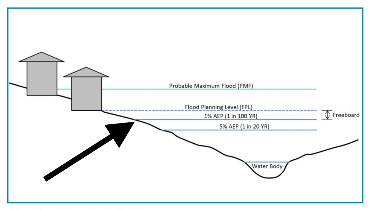
The image illustrates how councils assess different levels of flood risk and why a property may need to be built above a specified level. It also explains the relationship between the 1% Annual Exceedance Probability (AEP) flood event, Flood Planning Level, freeboard and Probable Maximum Flood (PMF).
What is a Flood Planning Level?
The Flood Planning Level (FPL) is the minimum level generally used by councils when setting requirements for residential development in a flood-prone area.
As illustrated in the image, the FPL is based on the 1% AEP flood level, commonly referred to as the 100-year flood level, plus an additional safety margin known as freeboard.
Depending on the location, applicable freeboard can be 500mm or 600mm, depending on the relevant catchment and council requirements.
In simple terms:
Flood Planning Level = 1% AEP flood level + Freeboard
For example, if hydraulic modelling determines that the 1% AEP flood level at a particular property is RL 100.00m and the applicable freeboard is 500mm, the FPL would generally be:
RL 100.00m + 0.50m = RL 100.50m
This level can have a significant impact on how a property can be developed.
What does the 1% AEP or “100-year flood” mean?
The diagram identifies the 1% AEP flood event as one of the key reference levels.
A 1% AEP event means there is a 1% probability of that flood level being equalled or exceeded in any given year.
It is often called a “100-year flood”, but this terminology can be misleading.
It does not mean that a flood of this magnitude will occur only once every 100 years. A 1% AEP flood could theoretically occur more than once within a 100-year period.
For property owners, the important point is that the 1% AEP level is a recognised benchmark used in floodplain planning and development assessment.
What is freeboard?
The diagram shows freeboard as the vertical difference between the 1% AEP flood level and the Flood Planning Level.
Freeboard provides an additional margin of safety above the modelled flood level.
There can be uncertainty in flood modelling because actual flooding can be affected by factors such as:
- rainfall intensity and duration;
- changes in waterways and drainage systems;
- blockages;
- debris;
- local hydraulic conditions;
- modelling assumptions; and
- variations between predicted and actual flood behaviour.
Freeboard helps provide a buffer against these uncertainties.
What is the 5% AEP flood level?
The image also identifies the 5% AEP flood event, described as a 1-in-20-year event.
A 5% AEP event means there is a 5% chance in any given year that a flood of that magnitude will be equalled or exceeded.
The 5% AEP level is lower than the 1% AEP level shown in the diagram.
This demonstrates an important principle of floodplain management: different rainfall and flood events produce different flood levels, and councils use multiple flood scenarios when understanding flood behaviour.
What is the Probable Maximum Flood?
At the top of the diagram is the Probable Maximum Flood (PMF).
The PMF represents an extremely large flood generated from the most severe combination of reasonably possible meteorological and catchment conditions.
Importantly, the PMF is not the same as the 1% AEP flood.
The diagram therefore shows a progression:
5% AEP flood → 1% AEP flood → Flood Planning Level → PMF
Each level serves a different purpose in understanding and managing flood risk.
A property may therefore be below the PMF level while still being capable of development, provided the proposed development complies with the applicable planning, engineering and flood-management requirements.
Why do councils prepare floodplain management studies?
Councils have an important responsibility to manage development within floodplains.
A floodplain risk management study considers the potential impacts of flooding and evaluates environmental, social, economic, financial and engineering factors.
The objective is not simply to prevent development in every area affected by flooding. Instead, floodplain management aims to determine how development can occur safely and appropriately while managing flood risk.
The resulting floodplain risk management plan can help councils determine appropriate development controls, infrastructure requirements and flood mitigation measures.
Why does this matter when buying property?
For property buyers, a flood-related planning control can have a much greater impact than simply the possibility of water entering the house.
Flood planning requirements can affect:
- whether a property can be developed or redeveloped;
- the permissible location of a new dwelling;
- minimum floor levels;
- site levels and earthworks;
- driveway and access requirements;
- drainage and stormwater design;
- subdivision potential;
- construction costs;
- insurance considerations;
- resale appeal; and
- the overall feasibility of a development project.
This is particularly important when purchasing a property because a large block of land does not automatically mean that it is suitable for subdivision or redevelopment.
A property may appear attractive from the street, but flood constraints could significantly affect what can actually be built on the site.
Flood risk does not automatically mean “do not buy”
A flood-affected property is not necessarily a bad property.
The key question is whether the flood risk and associated planning controls are compatible with the intended use of the property.
For an owner-occupier, the considerations may be different from those of an investor looking to subdivide or redevelop.
For example, a buyer may be comfortable purchasing an existing home where the dwelling and access arrangements already comply with relevant requirements. However, the same property could become considerably less attractive if the buyer’s strategy depends on constructing additional dwellings and the FPL or flood constraints make that development difficult or uneconomic.
The key takeaway
The image demonstrates that flood planning is not simply about whether a property has flooded in the past.
It is about understanding modelled flood behaviour, planning levels, safety margins and the implications for future development.
The 1% AEP flood level provides an important benchmark. The Flood Planning Level adds the required freeboard to provide an additional safety margin, while the PMF represents a much more extreme flood scenario.
For property buyers and developers, understanding these levels can help identify potential risks before purchasing and, importantly, determine whether a property’s intended use is actually feasible.
Before purchasing a flood-affected property, obtain the relevant council flood information and, where development is proposed, consider obtaining appropriate hydraulic, planning and engineering advice.
Flood controls and development requirements vary between councils, catchments and individual properties. The information above is a general explanation of the concepts shown in the supplied image and should not be treated as site-specific planning or engineering advice.